
Discover the Rivers of Pakistan
Journey through Pakistan’s lifelines—the Indus, Jhelum, Chenab, Ravi, and Sutlej—each shaping landscapes, sustaining agriculture, and nurturing the country’s rich history and culture.
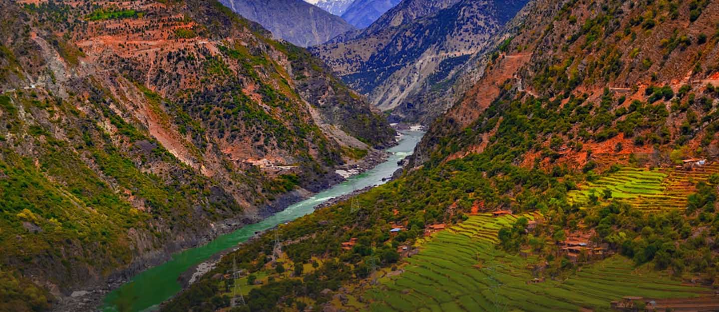
Seeing Pakistan serene, deep rivers was interesting. Anyone can immediately feel at ease thanks to the serene surroundings and gentle waves. Rivers are not only peaceful and beautiful, but they are also extremely important politically and economically. Rivers are utilised for irrigation and hydroelectricity, and they are a significant supply of drinking water. As a result, having them is essential to building a healthy economy.
READ MORE: Pakistan Top Forts: Showcasing Their Archaeological Magnificence
Pakistan boasts rich natural resources, historical structures, terrifying locations, and stunning scenery. It features lowlands, verdant meadows, stunning mountains, and breathtaking views of the seashore. It boasts the greatest medical facilities together with an advanced educational system. Pakistan is home to numerous rivers. Continue reading to learn more about Pakistan’s main rivers.
List of Pakistani Rivers
Pakistan is home to five rivers, specifically:
- Chenab River,
- Jelhum River
- Indus River
- Sutlaj River
- River Ravi
River Jehlum
The Kashmir Valley is traversed by the Jhelum River in both eastern Pakistan and northern India. With a total length of about 725 km (450 mi), it is a tributary of the Chenab River. There are a lot of fascinating legends around the name of this river.
Some say that after winning a string of battles, Emperor Dara arrived at the river, where he set his flag and called it “Jai Alam,” which translates to “Place of Flags.” People began referring to Jai Alam as Jhelum over time.
Some claim that Sanskrit is where the river’s name originated. The name of the river is derived from an illusory narrative. Legend has it that Lord Shiva jumped into the Vitasta River to end his life. It is listed as one among the principal rivers in the ancient Rig Veda.
At the Battle of Hydaspes in 326 BC, Alexander the Great led his army across the Jhelum River and vanquished the Indian ruler Porus. The river starts from the Virinaj spring, which is located in Kashmir at the base of the Pir Panja mountain. After there, it merges with its tributaries, the Indus River at Sadipora and the Lidar River at Karnabar in the Kashmir Valley. Before entering Pakistan, the river passes through Ural Lake and Srinagar.
The Kohala Bridge, which is located east of Circle Bakot, connects it to the rest of Pakistan as well as Pakistan Kashmir. After that, the Poonch River joins it and pours into the reservoir of the Mangla Dam in the Mirpur district.
The Jhelum River is connected to numerous lakes. Lakes consist of:
- Dal Lake
- Wular Lake
- Manasbal
- Gangabal
- Nigeen
- Anchar lakes
River Chenab
The Chenab River is the next item on the list because Pakistan has an abundance of breathtaking scenery and natural beauty. It contains everything from broad mountains and magnificent deserts to lush lowlands. Similar to the Jhelum River, the Chenab River divides Pakistan from India.
It starts in the Lahaul and Spiti regions of Himachal Pradesh, India, high in the Himalayas. From there, it runs through the Jammu region of AJK, enters the Punjab plains in Pakistan, and eventually empties into the Indus River close to the city of UchSHAriff.
Indians knew of the Chenab River since the time of the Vedic literature. Alexander the Great established Alexandria, today known as Ush Sharif, on the banks of the Indus River in 325 BC. Beas joined Sutlej, Jhelum and Ravi joined Chenab, and eventually Sutlej and Chenab merged to form Panjnad close to Uch Sharif.
The merged river travels 45 miles or more to the southwest, where it meets the Indus River near Missankot. The Indus River keeps flowing in the direction of the Arabian Sea.
River Ravi
A river called the Ravi flows through eastern Pakistan and northwest India. It is also one of Punjab’s six principal rivers that make up the Indus system. The waters of the Ravi River are Indian territory under the terms of the Indus Waters Treaty. Similar to this, the Indus Basin Project uses water diverted from the Indus system’s western rivers to replenish Pakistan’s Ravi River.
Ancient history, which dates back to the Vedas, refers to the Ravi river as Airavati. The source of the Indus River Basin and one of its most significant elements is the Ravi River.
The Ravi River empties into the Arabian Sea after joining the Indus River. Balabanghar in the Kangra district of Himachal Pradesh, India, is the river’s source. India’s river drains 14,442 square kilometres (5,576 sq mi) after flowing over 720 kilometres (450 mi).
The vegetation of Pakistan is significantly influenced by the Ravi River as well. Cedar, walnut, sisso, olive, mulberry, alder, table pine, twisted cypress, red pine, cedrela serata, sisso, and Kikkar are all within its jurisdiction.
River Sutlej
The Punjab Province is the source of Pakistan’s longest river, the Sutlej. It is a river that spans the boundary between Pakistan and northern India. The local tongue also refers to the Sutlej river as Sattadri. The source of the Sutlej River lies in Tibet, west of the Rakshasa Lake Basin.
The Indus Waters Treaty gives India ownership of the water of the Sutlej River. In addition, the river is below the Bhakra Dam across the Sutlej and above the Ropar Dam, with an annual discharge of about 14 million acre-feet (MAF).
Pakistan values the Sutlej River because it is crucial to the production of hydroelectric power. The Sutlej River serves as a model for numerous hydroelectric initiatives in Pakistan. The 1,000 MW Karsham Wangtu Hydropower Station, the 1,500 MW Nathpa Jakri Dam, and the 1,325 MW Bhakra Dam are some of these projects.
River Indus
The Sindhu River is another name for the Indus River. It was referred to as Sindhu in Sanskrit and Hindu by the Persians and was regarded as a “border river.” It’s among Asia’s biggest rivers.
The river passes through Pakistan, India (Ladakh), and China (western Tibet). The river empties into the Arabian Sea after passing through Gilgit-Baltistan and the Indian province of Ladakh.
The river’s annual flow is estimated to be 243 square kilometres (58 cubic miles), with a total drainage area of almost 1,165,000 square kilometres (450,000 square miles). Its topography is also incredibly fascinating. It starts in the Himalayan, Karakoram, and Hindu Kush mountain springs and glaciers.
The lower parts of the Indus River flow into a sizable delta, while the northern portion of the Indus Valley and its tributaries comprise the Punjab area. Pakistan’s economy depends heavily on the Indus River, especially in Punjab, the nation’s breadbasket, which produces the majority of the nation’s agricultural output.
These are Pakistan’s principal rivers. They support a number of other sectors of the economy in addition to tourism, energy production, and agriculture.
Comments are closed, but trackbacks and pingbacks are open.